Sunday, 26 January 2014

Day2: Leh Manali

Having crossed the 5000m altitude mark 7 times by now, there was considerable confidence of crossing over Tanglangla. Claimed to be the 2nd highest(3rd according to my GPS) motor-able pass. The BRO had built a runway on the hills. The climb was a long one with only short patches that were bad. It was a  good broad road with snow on the sides as I moved higher. I was fortunate to have a glimpse of the Himalayan Pica (a cute rodent) which I later managed to capture (persistence).
The road makers were finally found at the pass.
On the climb to Tanglangla

Road to heaven! Hats off BRO

Himalayan Pica
 The descent from Tanglang la was not as
comfortable. It was practically a bumpy slush ride and the road dried up to dust as I reached a terrain relatively plain but with a punctured tire. Not having used the new tire that I carried all along, I decided to put it on to avoid the cleaning part during the puncture. I was nearing morey plains and water was a precious resource now that shouldn't be wasted. After plenty of rough riding on miserable terrain this was the first flat in this state... the tube had given up.
Not much climb was what I assumed and overall some more descent to Pang. That was correct and this ride seemed to be more pictursque than any before. It was one of the riding days with most number of snaps taken. Now came the morey plains which I had been warned about for shortage of water. Apart from enjoying the terrain and wondering why this was so inhabited, there was a major question that I had to answer. How to survive here? It was an important one. The terrain was flat, the road was good and I had less than 50 kms to cover to find Human company but then there was the terrible headwind.there was no escaping and every now and then, I considered a plan-B of setting on under some rock. Water would not be a problem. There was snow and some puddles were observable at my service. I had let Tso kar pass which was an offroute. Should I have visited there and tried out my survival near a lake? The most reliable thing to do was to pedal hard even if it got dark. I did not expect the wind to reduce at nights.
But these natural threats are always welcomed when the views are pleasing:
towards one end of the morey plains, one can find shrubs, sheeps&yaks, shepherds

The Morey Plains

One such puddle that gave me considerable confidence
While the pedaling continued, it was about to get dark, I came across a view to my left.. It was a gorge. Can't do the justice to the view with my snaps but they reveal more than the words. Here's the pic:
The gorge was pleasing. The hills to my right reduced in height and I saw the sun. It grew a bit brighter here. There was water and a gorge is suitable for survival. But looking down and following the river I got the relief. Below was Pang. It was a small downhill and I reached the bottom. I was no longer tired and granted myself a holiday for exploring the gorge. It was exciting to stay up at night and catch some glance of the gorge but it was too cold. Not that I wasn't out.
Following day(day3) I walked up the river. Though I didn't seem to move quite far and that aspiration remains to trek further to the end of this river. Probably they are the mountains at the horizon. Apart from the wild asses and some birds, I saw the humans(locals) on my return to Pang
There is pleanty of room(warm tent cum restaurant) to stay and most of the tourists put up here. Some motorists after meeting the challenges on the route from Manali to Pang get so determined to reach Leh(>200kms) that they take up the ride even in the dark which seems more of an escape. Roads on passes could be icy at night and this stetch is one of the most picturesque.

Wednesday, 22 January 2014

Day1: Leh-Manali

Karu-->Rumtse
Karu(around 40km after Leh on way to manali)
Ride to Rumtse is a short one and I got to see great roads being constructed by the ever hardworking BRO. Upshi comes on the way where one can decide to go to Tso Moriri. I always had that in my plan but towards the end had procrastinated it for a next trip. The terrain in Ladakh is ever changing. Initially reminded me of the sharp and brittle Stok Kangri region and very soon it changed to rounded hills. Crossed by a Pashmina goat farm and some villages. One can find plenty of places to put up in Rumtse but most bikers targetting from Manali or Leh often skip this place as it is too close to Leh for them to halt.
There is a monastery as well worth visiting.
Chukar: a common bird in the region

Village farms on the way to Rumtse

Reminds me of Stok Kangri(first place where I saw such eroded terrain)


Pashmina farm near Upshi

Hiked up a pass and was surprised to find some signs of habitation


Wednesday, 18 December 2013

Further East in Ladakh

A ride from Tangtse to Chushul (near the Indo-China border) and once again some changes in terrain, fauna, people. Very few changes that were observable in the flora (anyways there is hardly any). It is said that earlier there was no vegetation in the eastern part but the DRDO took up the initiative and replicated the vegetation of western ladakh. This is evident if one compares the Aksai Chin to Eastern Ladakh which is not visited much due to military reasons. The black necked crane (state bird of J&K) is finally seen here.


black necked crane

crossing a 5000m pass (unnamed). Easy terrain: gradual and wide

Coming up in future posts, is the most fantacized route: Leh-Manali

PangongTso II some more angles


brown and black headed gulls are present during summers

A full moon over a lake is a delight!

Friday, 1 November 2013

PangongTso

Some of the best landscapes we saw
Crossing Changla took me quite long as expected. Crossing high passes keeps getting tougher with every metre of climb. The downhill there after was initially tough due to the snow-ice forming on the road. But crossing Changla after 3 has its advantages. There are no vehicles moving in my direction and the ones opposing also reduce in numbers leaving a great downhill to enjoy with thrill or just sit on the saddle and feel the serene valley. I was involved in both and many times looking down below at the valley did resemble like flying in a chopper but that thrill I tried to avoid on downhills least the reality and the dream coincide!
After a night halt at Tangtse, I moved off early to the nearby lake of Pangong. Any body coming from Leh will take their time to cross Changla and anybody at Pangong would not be willing to leave the place in the morning. My prediction was right again and I got the deserted road with occasional visitors like spectacular birds, wild asses, Yaks, goats and the BRO. The rides in these regions were one of the best I ever had.
The Pangong has a rich dark blue colour while under the sun. The colours vary quite a lot with time and it is fun to watch the variations especially from an elevation. Climbing on to hills, I was fortunate to have the perfect view (well one of many).
One of the perfect Pangong view
Bird watchers would be delighted at the number of Siberian visitors and other locals.


Tuesday, 15 October 2013

Eastern Ladakh II : ChangLa

ChangLa was the second big pass (5000m+) that challenged me. It was a slightly longer uphill than the one at Khardung La. I started from a slightly higher altitude (Karu base) as compared to Leh market and the slopes were also more challenging on this route. Aware of the old controversies over the altitude of KhardungLa, I had measured them with my GPS. So did I repeat the procedure at ChangLa, resulting in ChangLa being the heighest Indian motorable road and fortunately with lesser traffic(due to lack of the title KhardungLa possesses) and better roads(so far all comparisions made with KhardungLa). I was expected to be acclimatised and so was I but honestly, the head still ached terribly. The slightly uncomfortable bumps seemed dangerous. It wasn't as bad as KhardungLa where I had to stop a lot more just to stay safe but here too I wanted to cross over early. No matter how fast I coevered the initial 75% of the mammoth uphill, the latter 25% (last 12kms) took more time than the earlier. And if one digs into details, it so happens that last 3 kms took over an hour! It kept getting tough as the roads further got bumpy. It is on these kinds of upslopes that the rear tyre skids and instinctly I tried to pedal harder.
Reaching the top felt like an achievement. The army offers free tea to all the tourists and takes good care. I was the special guest at that moment being welcomed, cheered, encouraged and well fed :)
The high passes usually have a tough downhill around 10kms on either sides(an exeption of TanglangLa- see future posts). This was no exception. The melting ice had made the road into pebbled rivers and the freezing fingers had to be kept alive.There after it was a neat speed and scenic ride till Tangtse. The sense of complete freedom was relished the most in eastern Ladakh though a man is never completely free. I had the borders and military restrictions at many places for my own good. The place had more of endangered species of animals than the least concern homo sapiens.
The heighest road under my consideration: Great Job BRO

Yaks feasting on whatever little icy grass they can manage

Saturday, 28 September 2013

Eastern Ladakh I

Leh has a lot of cultural display regarding Ladakh, but due to commercialization, it is bound to change. The prosperity has led to modern buildings. To have a look at 'not so modern' Ladakh, one has to move away to Karu or Upshi or even further to Rumtse. Eastern Ladakh starts showing of variations in terrain as well with more vast open spaces and a higher elevation. After crossing over Khardungla on my return, I ended up in Karu and perched around near by villages. This was the longest stay as I had to wait for the fantastic Leh Manali route to open up. Meanwhile, I explored Pangong Tso and Chushul regions. Eastern Ladakh stays the best part of the journey with lots of scenic moments and good tough experiences. The heighest passes were fought in this region. 7 out of 10 times I crossed 5000m altitude mark on the bike. While some say it was the man not the machine to achieve such feats, I would have to agree. If it weren't for Mr. Cannondale, 12000cc of thighs would not have scaled the heights so efficiently and quickly!
Solar Cooker. 2 houses: an old and a new one
On the way to Pangong Tso

Chemrey Gompa cluster on the hill

Tsoltak: snowed on ChangLa

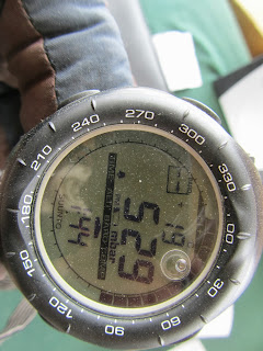
529mbar of pressure on Changla! almost half of that at sealevel! Killer...